Image Segmentation
The Image Segmentation panel provides several methods for segmenting your image dataset. Image segmentation is the process of transforming your image data into a 3D digital model of your sample. In GeoDict, this digital model is called a structure.
Learn how to use all the tools available to you to segment your image: |
|---|
|
Comparison of different Segmentation Methods
To compare different segmentation methods, a Berea sandstone sample (Andrä et al. 1-2013, 2-2013) was segmented using Global Thresholding, Multi-Phase Segmentation, and AI Segmentation. See the figure below for a comparison of these methods.
This dataset has dimensions of 720x720x1024 voxels and a resolution of 0.74 µm. Its material components are quartz, feldspar, calcite, and zircon.
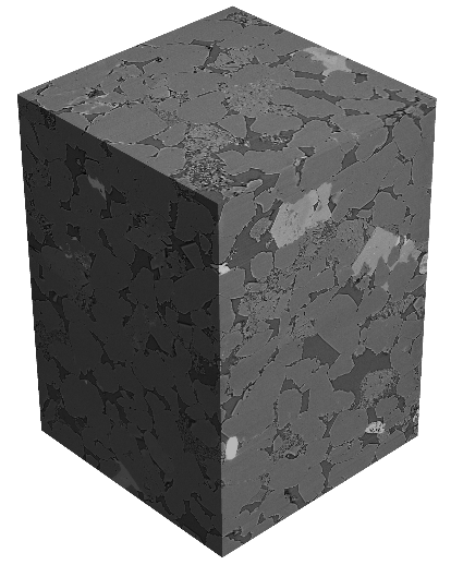
A parameter study was conducted that compared published experimental data with GeoDict results. Segmented porosity and computed absolute permeability were determined for the different segmentation methods. The results showed that the Non-Local Means Filter was not necessary for the AI segmentation but was necessary for the other two methods. After segmentation, any remaining small-scale features were reassigned using the ProcessGeo Cleanse feature.
The figure below shows the segmentation results for the different methods applied to the Berea sandstone. A visual comparison shows that the Global Thresholding result is very similar to theAI Segmentation result. Multi-Phase Segmentation removes most of the small-scale features. Thus, reduced porosity is expected for this result.
The comparison study shows that all of the above segmentation results fall within the range of the experimentally obtained data. Flow computations performed via the FlowDict module result in absolute permeability values that fall within the range of published laboratory data by Andrä et al., 2013. The entire study, Impact of different segmentation methods on Digital Rock Analysis results, was presented at the 2020 iRIS (International Rock Imaging Summit) conference and is available on the GeoDict website.