Importing Image Datasets
Select Import → ImportGeo-Vol in the menu bar to convert volume and image formats, such as micro-CT scans, into 3D material models. The ImportGeo-Vol module section opens on the left side of the GeoDict GUI.
Load the Image Dataset
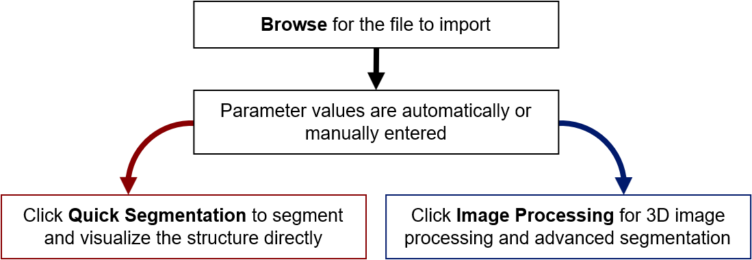
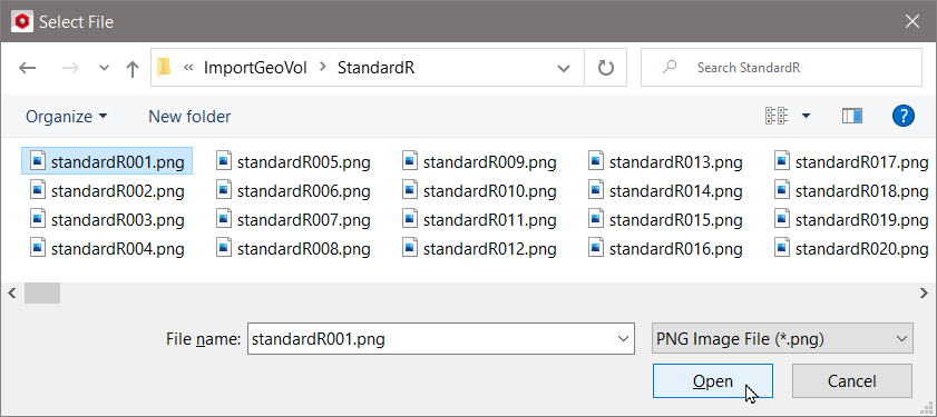
Click Browse to open the Select File dialog. Select either a single 3D image file or an image in a folder containing an image stack. Then, click Open.
Geometry Import Dialog
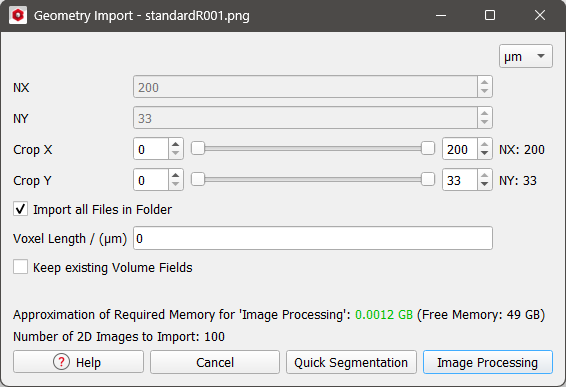
After clicking Open, the Geometry Import dialog will open automatically. Depending on the file format, a dialog opens containing various options and parameters in preparation for the import. For most formats, the size of the geometry in the file is automatically entered. The approximately required and free memory amounts are displayed to indicate the available working memory.
Dimensions and Cropping
NX, NY, and NZ specify the size of the structure in voxels. For most file types, these values are read and entered automatically. For RAW format files, you need to know these values and enter them here.
The double sliders allow you to restrict a section of the 3D image to be loaded. The left-hand sliders define the number of voxels which are cut away at the start of the image in each direction, and the right-hand sliders define the last pixel to be imported in each direction. By default, ImportGeo-Vol imports the complete image. The values for NX, NY, and NZ, and the first and last voxel positions can be changed for very large images that would not fit in memory. It is possible to focus on any sub-cuboid of the original image by adjusting the sliders.
Below the the size of the file’s structure and the cropping options, define the Voxel Length in the selected unit.
|
Note! The available units (m, cm, mm, µm, nm and Inch) are selectable from the pull-down menu at the top right of every dialog. |

Keep existing Volume Fields
Check Keep existing Volume Fields, if the currently loaded volume fields, e.g., previously loaded image datasets should not be discarded. This is useful, if more than one image dataset should be used for AI-Segmentation labeling and training.
Segmentation and Processing
For most importable file formats, the size parameters are automatically entered after browsing for the file and loading it. Click Quick Segmentation to load the images saved in the selected file and display them in the visualization area. All supported file formats can be processed (i.e., the geometry can be cut, resized, rotated, filtered, and segmented) before the file is finally imported into GeoDict.
At the bottom of the dialog, two options for continuing are available:
- Quick Segmentation: For many of the importable file formats, the structure is directly loaded after clicking Quick Segmentation.
For other files, such as *.raw image files, or stacks of *.png files, that are considered a three-dimensional image with gray values (e.g., from 0 to 255), clicking Quick Segmentation opens the 3D Image Quick Segmentation dialog. This dialog shows a histogram with the number of voxels for each of these gray values and enables a simple global segmentation without further 3D Image Processing. - Image Processing: Allows for more complex image processing, e.g., changing image sizes or orientation, filtering the images, and finally creating a segmentation.